A photo just doesn’t do the Te Puia bubbling mud pools justice. I was mesmerized, watching them pop up and flatten down. If there were such things as witches’ cauldrons, I imagine they would look exactly like this.
But the real show was the Pohutu Geyser.
Hmmm, that wasn’t all that special…but wait…
It’s getting better…
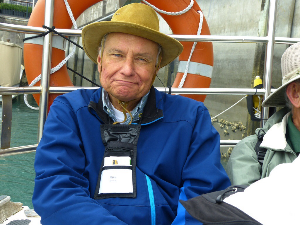
Our guide, Albert, took this photo of Mike.
Mike’s quite a distance from the geyser, so it gives you an idea of the size of the water column. But there is more to come.
NOW you’re talking!
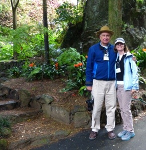
Speaking of Albert, here he is with our Maori guide.
While I was busy photographing Albert, Mike was surrounded by a crowd of Asian women. Just like in Thailand, but this time only one wanted to be photographed with him, so I wasn’t fast enough to capture the scene. Mike was only to happy to explain to me that his new friend told him he was very handsome…
But back to the tour. After viewing the geological wonders, we visited the woodworking school.
This one is my favorite.
I didn’t think that anything could come close to being as glorious as yesterday’s experience in the Waitomo Caves. I was wrong. The Waimangu Valley Geothermal Site was equally magnificent, but in a very different way. This valley is the only geothermal system on the planet that was created by a volcano–the Tarawera eruption of 1886.
The result was Lake Rotomohana. Our group was divided in two, with half cruising the lake first while the other half hiked, and then we switched. Our boat was the only one on the lake that morning, and with only 18 passengers, it was easy to get an unobstructed view of all the geothermal phenomenon. Before the volcano erupted, what is now Patiti Island was part of a small hill. It became a lava plug, cooled, and is now home to cormorants.
The steam vents fascinated me, so I kept snapping away.
The hike gave us the opportunity to get close to craters and geysers. The lake water is acidic. It looks like it is boiling because of the gases (carbon dioxide and hydrogen sulphide) bubbling up to the surface.
Here is our smiling guide Chas, holding a silver fern, one of New Zealand’s symbols. Do you think he usually carries a Winnie the Pooh back pack in front? Something to look for in future installments. More bubbles, then time to head back for lunch.
Pretty amazing, right?
Once again, our guides came up with a great lunch venue. The Princess Gate Hotel has it all: an owner that welcomed us with a brief history of the hotel, fantastic food, wonderful ambiance, and a location close to the most beautiful section of Rotorua.
After lunch, we had time to stroll through the gardens, and ogle the beautiful buildings.
A long drive is a pleasure when you have Albert and Chas on board. Their commentaries are educational AND entertaining. Have I mentioned that the Kiwi sense of humor is quite delightful?
The bus is very comfortable and quite spacious. We were grateful to have our skillful driver Andrea behind the wheel, navigating the winding single lane highways and byways to Rotorua. But first we stopped at Roselands for terrific barbecue lunch. This is definitely NOT a weight loss trip!
The view from Roselands was typical New Zealand: green rolling hills, with sheep grazing on the hillside.
The rhododendron were in bloom and were spectacular.
Our next stop was the Waitomo Caves, the home of the awe inspiring glow worms. Here’s what happens. You walk with a guide through caves with interesting stalagmites and stalactites. All very nice, but I had seen similar versions in both the US and Halong Bay. Then we entered a boat, and floated into pitch darkness and complete silence to witness a breathtaking phenomenon. We weren’t allowed to take photos, but postcards are a good alternative. So, this will give you a very rough idea of what it was like.
My new friend Mel (and yes, we have bonded already, so whether he likes it or not, he has become a friend for life) wrote this beautiful poem that sums up the experience better than I ever could.
“In the darkened stillness, the glowing pinpoints embrace me, reminding me that, as ever, there is a spirit that guides me.”
It was definitely a peak experience, and one that I will never forget.
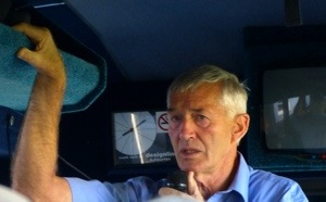
Have you ever experienced an inspiring teacher? Been completely enthralled by a lecture? That is what our entire third day was like, being with the amazing Dr. John Walsby. He is truly a Walking Wikipedia — botany, geology, history, architecture, zoology, marine biology–you name it, he can speak at length about it. Although his extensive knowledge was impressive, what was most memorable was his delivery. He talks with his entire body. For example, he didn’t just say “boom” when describing a volcanic eruption — instead, his whole body exploded–with arms and legs flying in all directions. Dr. Walsby is a writer, an artist, a marine biologist, the author of 5 books, weekly contributor to Nature Watch, a newspaper column, and one of the most entertaining and memorable speakers I’ve ever encountered. So, what did we learn?
Although we tend to lump Australia and New Zealand together, that island just to the west of New Zealand is about 1,200 miles away.
New Zealand’s weather is influenced by its location midway between the equator and Antarctica. It gets warm air from Australia and cold air from Antarctica, which makes for plenty of rainfall. The North Island gets many brief showers, averaging about 4 feet per year. The joke is that Auckland gets all four seasons, frequently within the same day. Despite cloudy skies in many of the photos, the weather has been quite lovely!
Some of his more memorable analogies:
The earth is like an egg cooked in a microwave: a solid core surrounded by an ocean of magma with a cracked crust.
Volcanic activity is like tea being brewed on the top of Mount Everest or a bottle of champagne being uncorked, with the crust on top being the cork. Important fact–volcanoes don’t erupt in the same place twice. Once it goes dormant, it is done.
The formation of New Zealand was compared to a scab that formed on your knee (the knee being Australia) that gets “flicked off”.
Our first stop, Lake Pupuke, was created from a volcanic eruption. A mile across and a half a mile deep, it supplies fresh water for the nearby town of Devonport.
Here is Dr. Walsby, demonstrating what happens when a pukeko gets frightened. The pukeko flushes a white tail to warn his compatriots of impending danger. Had I been faster with my camera, I would have caught him flashing the white handkerchief tucked into the back of his pants.
And here is a REAL pukeko.
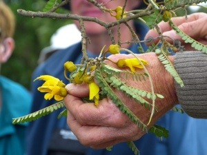
This beautiful flower is fertilized by birds, rather than insects. It’s “lady parts” are on the outside, rather than the inside of the flower to make it easier for the birds to do their important work. Can you see the long appendage?
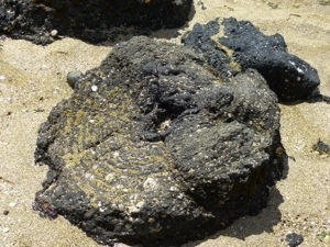
Our next stop is Takapuna beach to see the fossilized trees. When the lava flowed from the volcano, the trees were snapped at the base, with a portion of the trunk remaining. It became encased in hot lava. The flows are clearly visible around what was once a tree trunk.
Dr. Walsby in action.
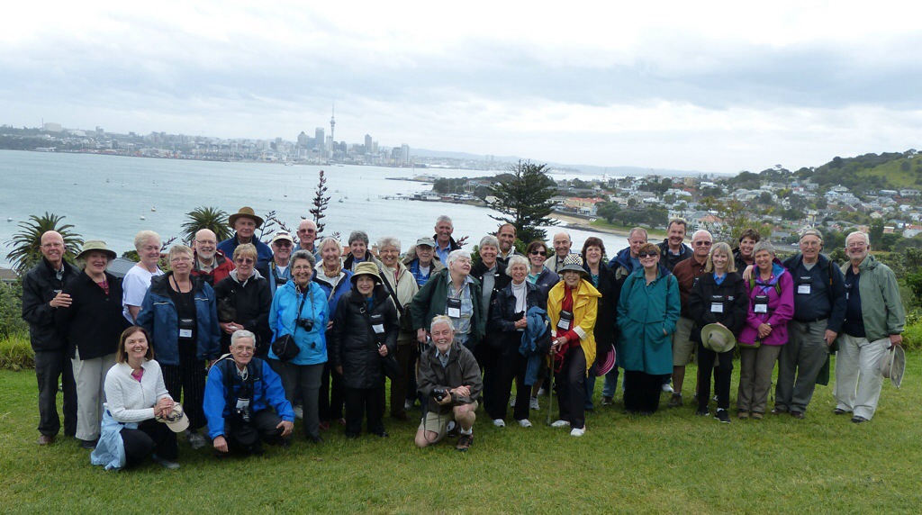
Our final stop was at North Head, a great spot for our group photo.
I’m not pressing my luck–I’m going for the upload! Thank you Queensland Airport!
Mike and I are actually on the final leg of our Road Scholar trip, but our many activities and the wifi limitations resulted in blog lag.
Day Two had a whole lot more going on than just the boat trip, however I had a chance to upload the prior blog while waiting in line at the Queenstown airport, so I went for it. That’s about all that I was able to go for, because our flight was cancelled. Seven of us didn’t make it onto the replacement flight. So, instead, we get a voucher for $12 worth of food, a couple of hours hanging in a very pleasant airport, and a direct flight to Wellington rather than a stop over in Christchurch. Not a bad deal, I would say.
So, to continue.
Road Scholar normally has very good guides, but Chas and Albert are in a category all their own. I think I have been spoiled forever, because these guys are beyond fantastic. They are patient, interesting, knowledgeable, funny, and in a very nice way are able to shepherd our group of 34 individual personalities. Now that’s what I call skillful! They have also done a terrific job finding exotic spots for lunch.
We were able to wander through the aptly named Eden Garden, enjoying the flowers, before dining on site.
Here are Adam and Eve, being careful not to eat any apples, but then, New Zealand doesn’t have any snakes to tempt us.
Our final excursion of the day was to Auckland War Memorial Museum. The New Zealanders lost a significant percentage of their population in the two world wars, and they now want nothing to do with armed conflict. Yet another reason to admire the Kiwis
And speaking of kiwis, they are nocturnal creatures, so this is probably the best sighting we are going to get.
One of many beautiful Maori carvings.
I’m going to quickly upload before I run out of MBs!
One of the many reasons we thoroughly enjoy Road Scholar trips is their high quality lecturers. Wednesday morning, New Zealand journalist and author, Gordon McLaughlin, gave us a brief overview of this very young nation. Some interesting facts and figures:
New Zealand is the last land mass to be inhabited, settled by the Maori about 800 years ago. DNA analysis has proven that the Maori migrated from Taiwan, providing a perfect example of Darwin’s theory of survival of the fittest. The long ocean voyage was an endurance test that only the strongest, biggest and fittest could pass.
In the 1840’s, the Maori were joined by settlers from the United Kingdom, with the those of European descent now making up the majority of the population. About 3.5 million live on the North Island, mainly in Auckland, with about 1 million inhabiting the South Island.
New Zealand was the first country to allow women to vote, in 1893; at one time the top three government positions were held by women.
In 1898, New Zealanders instituted an old age pension, with free health care since 1938. Seems Kiwi are not horrified by the thought of “socialized medicine”. And it doesn’t seem to have impacted their quality of care because their life expectancy exceeds that of US males by 3 years, and a year and a half for females.
Both countries have similar percentages of those over 65, and under 15. Education is free, including some university and trade schools. Pensioners also enjoy a variety of freebies, such as train and boat transportation, admission to museums, etc. So how do they pay for all of the free services?
The top tax rate is 35%, with a 15% GST (goods and services tax) built into their prices. So, when dining out, a menu item priced at $25 means that you actually PAY $25. Tax has been included and the wait staff has been paid a reasonable wage, so tipping is only for extraordinary service, and even then is about half of what is customary in the USA. I guess if you are not bristling with weaponry and fighting senseless wars, you have money for such things.
New Zealand is geologically young –a mere 12 million years old. If you have ever walked along the Trail of Time in the Grand Canyon’s South Rim, you may recall that equates to only 12 of the trail’s 2,000 footsteps. If you haven’t been there, each footstep represents a million years. Samples of rocks from that particular era exhibited along the trail–starting 2 billion years ago, which is the age of the oldest rocks in the canyon.
Years ago, there were no mammals on New Zealand, so the birds had no predators, which resulted in flightless birds, like the Kiwi.
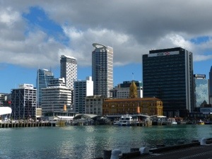
Sitting atop two tectonic plates, New Zealand has an abundance of hot springs, geysers, and mud pools, all of which we will see when we visit Rotorua. But for our second day in Auckland, we are scheduled to sail in Waitemata Harbor.
View of Auckland from the water.
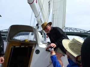
It looks like it is going to be a tight squeeze under the bridge. That’s our North island site coordinator, Albert.
Not to worry, there is an experienced skipper at the wheel.
Is that a concerned look on that passenger’s face?
The Road Scholar portion of our journey began on Tuesday, October 29, with a walking tour of downtown Auckland. This city has lots of interesting architecture, much of it newly constructed, so that it is earthquake-proof.
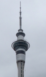
The sky tower is visible from just about everywhere in Auckland, but during our stroll we managed to catch someone jumping from the tower. See that little black speck in the lower right hand corner? That’s him, and yes, it IS an approved activity. The Kiwi are very big on bungee jumping. And no, I had absolutely no desire to “give it a go”, as they say down here.
We ended our walk at the Art Museum, which has a wonderful gallery of Maori portraits. We weren’t allowed to take photos there, but this postcard gives you an idea of what a tattooed face looks like.
As one might expect, the facial swelling from face carving is fairly severe. the guide showed us a large funnel, which functioned as a feeding tube while the facial wounds healed.
I as quite captivated by the flower sculpture hanging from the ceiling in the entryway. The petals move!
Auckland has a number of incredibly beautiful parks. The museum is next to one–Albert Park has this interesting entryway, and we did a quick walk by after our excellent lunch at the museum cafe.
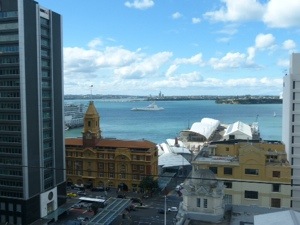
Our hotel has two things going for it: a great location near the harbor, and a spectacular view from the restaurant on the 13th floor.
I told told you you could see the sky tower from everywhere!
We had just enough time for a brief walk around the waterfront before joining our group for dinner. This picture is for our former host, Norman, to show him that we actually DID see some tall ships!
New Zealand is an amazing country with many things the USA could learn from, but their wifi isn’t one of them. It is very limited, and blogging is a challenge. So, uploads are being done on the fly, and proof reading is a luxury to be reserved for better connections and more time. Typos will become a regular feature!
Lonely Planet has proclaimed that Auckland is one of the ten best places in the world to visit in 2014. Although I concur with their choice, I would have moved Auckland to the number one spot. But then, Mike and I had something Lonely Planet didn’t– New Zealand’s best tour guides, Norman and Davina, which definitely influenced my rating.
Let the tour begin!
It’s hard to believe that we spent only four days with these very gracious hosts, because we saw and did so much. It was all wonderful: breathtaking scenery, with beautiful beaches, but what made it extra special was the time we spent with their wonderful family, which gave us the opportunity to experience Kiwi culture and daily life.
This post is my way of saying thank you to Davina and Norman for a fantastic visit. I can’t capture ALL of the high points of our time together–there were just too many, so I’m limiting myself to 10 memories. Here they are, not in any particular order.
1. One Tree Hill
Auckland, Viewed from One Tree Hill
The Auckland area has more than 50 extinct volcanoes. This is a relatively young crater, a mere 500 years old.
You can go into this Volcanic Crater
2. The “Bach”
According to Wikipedia, the term originated from “bachelor pad”, but it has now come to mean a New Zealand summer home for family vacations. We stayed at our hosts’ family bach.
The bach
New Zealanders welcome drop ins, (or at least Davina, Norman and their friends do. I really shouldn’t generalize that ALL New Zealanders are like them, because they are rather special). Anyway, we got to see yet another bach, in Whitianga, right on the beach, when we popped in to visit their friends.
The view from the Bach living room
3. Whangamata
No only did we visit this lovely seaside resort, we also leaner how to pronounce its name. The Maori way sounds like this: Fong-ahh-mat-AHHH.
Strolling along the beach
I’ve never used a public toilet that had piped in music and recorded instructions for locking the door, including a warning that you had best be done within 10 minutes. I thought it might be a New Zealand thing, but no–so far, it has only been a Whangamata experience.
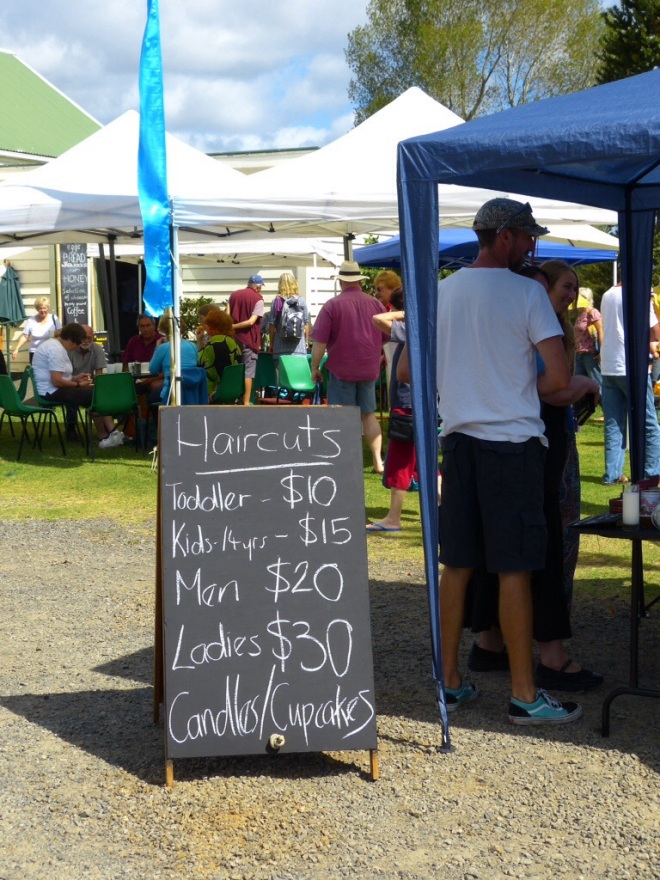
4. Farmers’ Markets
Had I known that I could get a haircut by the side of the road, I wouldn’t have been in such a rush to get a trim before we left.
Farmer’s market,on the way to Whangamata
5. New Chums Beach
I don’t know if this is the most beautiful beach in New Zealand, because EVERY beach I’ve seen so far has been rather wonderful. I think we just TOLD ourselves that it was the most beautiful because we had to walk over rocks and through rain forest growth for about 30 minutes to get to it.
How much further????
It DID have a rather nice swinging rope, though.
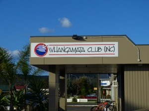
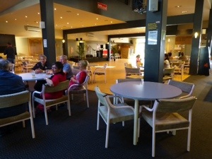
6. Saturday Night at “The Club”
In the USA, we don’t have anything quite like a New Zealand club. Take a casino, a restaurant, a pool hall, a sports bar, a cocktail lounge, a dance hall– mix it all together, but make it family friendly and voila, you’ve got yourself a New Zealand club. Best of all, members of one club can use any other club. Sounds good, doesn’t it?
The club in Whangamata
7. Lost Spring Thermal Pools, Whitianga
No photos for this one. We sat in a natural hot spring surrounded by lush foliage and beautiful flowers. You’ll just have to take my word that it was quite glorious.
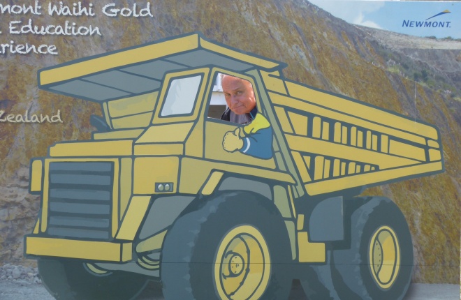
8. Waihi Picnic
We were only in Waihi a short time. Just long enough for us to have a great picnic lunch atop a hill, check out the gold mining operation, and for me to buy a Kiwi cap.
Trucks appeal to boys of all ages
9. Karangahake Gorge
A bike path runs through this area. Biker chicks, take note!
Gorgeous GorgeNew Zealand – Clean and green
10. Family, Friendship, Fun
Spending time with Norman and Davina’s family made our time before the start of our Road Scholar trip extra special.
I had a chance to see how “socialized medicine” works, when I accompanied Davina to Taylor’s visit to the dentist. The offices are located on school property, and there is no charge for the visit. Brig, clean offices, a short wait, at no cost. What’s not to like.
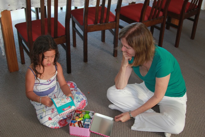
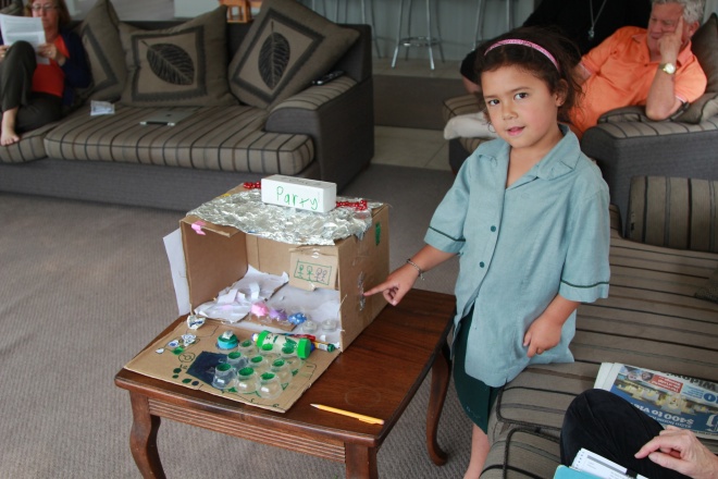
Davina and TaylorPippa, explaining the rules of the gameThis is one creative little girlThis is the “walking school bus”
Time to hit the road again! For years, Mike and I have wanted to visit New Zealand, but we knew that a twenty hour plane ride could only be justified by a loooong stay. So, visiting that wonderful corner of the world had to wait until my retirement. Although I had been able to get away for three weeks while working, SIX weeks didn’t seem do-able.
Mike and I were so lucky to meet Davina and Norman on a river cruise in 2008. Our fellow cruisers were were almost evenly divided into thirds, from the USA, Canada and Australia, with Davina and Norman being the sole Kiwis. It was during a presidential election year, which made dinner discussions VERY interesting.
I’m amazed at how well informed other citizens of Planet Earth are! Makes me want to listen to the BBC more frequently, so I don’t embarrass myself with my ignorance of events outside our borders. Of course, Ted Cruz has done a good job of making me embarrassed by what has happened INSIDE our borders!
And yes, there actually IS a reason for that digression. Mike and I will be staying with Davina and Norman in Auckland for several days before our Road Scholar trip commences. I’m excited about spending time with them again, and have been blown away by their gracious hospitality. Davina offered to pick us up at the airport at the ungodly hour of 6 AM! And she has planned several days of sightseeing for us.
Getting maps into WordPress is a multi step process, easier done from my computer than iPad, so I figured I’d get it completed before we head to the airport.
First a map of the ground we will be covering during our Road Scholar trip.
Our New Zealand Adventure
At the end of that trip, Mike heads back to the USA and I start a three week project with Global Volunteers in the Cook Islands. So, where ARE the Cook Islands, you ask?
The Cook Islands
Because I will be crossing the date line, I’ll be arriving before I leave. Given that I have always been calendar challenged, this will not be a problem for me.
If you look at a map of the world, the Cook Islands show up as fifteen tiny dots, so here’s a close up of “my” island.
My home for three weeks
I’ll be staying in Rarotonga, the largest of the islands, which has a population of around 9,000. That’s about twice as many people as my home town.
I found this description of Rarotonga on the internet: “The island is one of the most beautiful in the South Pacific making it popular with around 90,000 visitors each year. The volcanic peaks and white sandy beaches with overhanging palm trees, inside a coral reef make Rarotonga a paradise island.”
Pretty tough duty, wouldn’t you say?
So, over the coming weeks, Mike and I will be hanging out in gloriously beautiful places, and I will be doing my best to capture all that fantastic beauty for your viewing pleasure. Who knows…maybe a contest down the road?
Come on along! And feel free to comment, so I stay connected with everyone!
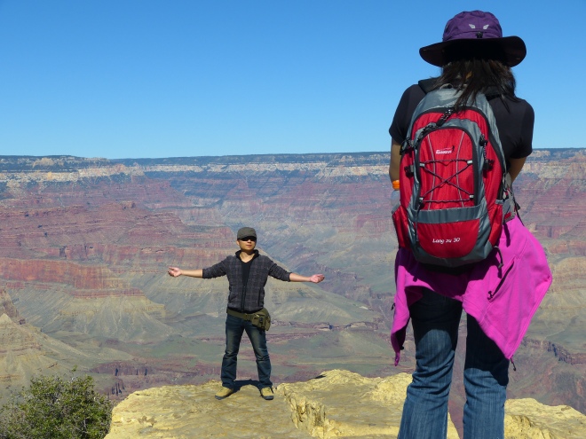
Magnificent! Spectacular! Those adjectives are far more accurate descriptions of the natural wonder that we call The Grand Canyon. It is very difficult to capture in a photograph the enormity of this “hole in the ground”.
An early explorer, with the catchy name of James Christmas Ives, was unimpressed. He dubbed it a “profitless locality” and predicted “the Colorado River, along the greater portion of its lonely and majestic way, shall be forever unvisited and undisturbed.” Had cable news been around during his day, he might have had a brilliant career as a pundit. (I leave it to you to decide which station would hire him).
After meeting at the Scottsdale Cottonwoods Resort in Scottsdale, our group of 35 headed off to the Hualapai Lodge in Peach Springs via Sedona and Flagstaff. Our hotel is on the reservation, right by the railroad tracks. Somehow that image didn’t make it into the hotel’s decorative window.It occurred to me that the trains’ engineers might have been a little annoyed that they were working while others were sleeping. That’s the only explanation I can come up with for blasting the horn multiple times as they approached the town. And yes, there were many, many trains–about 1 every 15 minutes. Made me feel really sorry for the people who live in the Peach Springs.
The big attractions for the western Canyon were the helicopter rides down to the canyon’s bottom, river rafting to Lake Mead on the “snout rigs”, and the Sky Walk.
First the Sky Walk. It wasn’t quite what I had envisioned. We didn’t go out on it, but we saw it from the top of the canyon,
View of the Sky Walk from the rim
then later from our river raft. It’s that silver oval, jutting out from the top of the photo. What do you think? Worth an additional $70?
View of the Sky Walk from the Colorado River
We didn’t think so either.
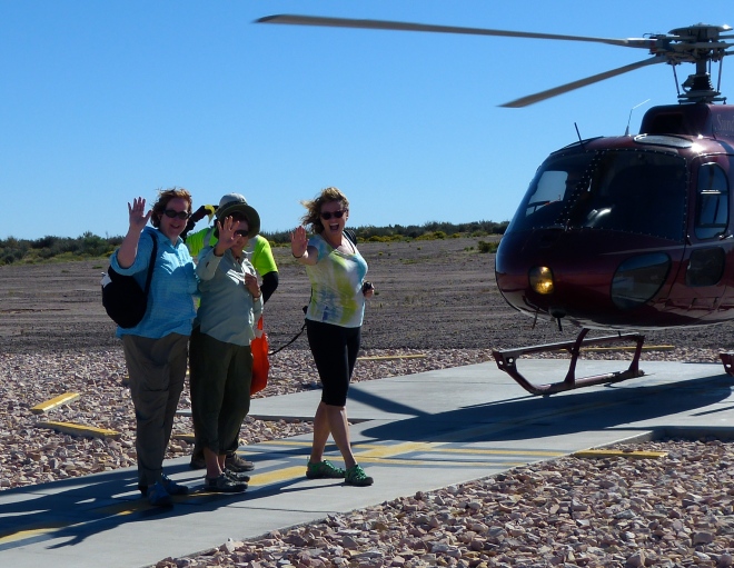
Back to the western canyon–here’s the view from the rim–very subdued colors, with a sediment laden river (that very brown ribbon) winding along the bottom. The Colorado River is quite low because of 12 years worth of droughts and the additional water needs of the area’s growing population. Mike and I were in the last group of chopper riders, so we had time to become “one” with the landscape and to take pictures of our new friends as they climbed aboard.
The flat Colorado Plateau gave no hint of what was close by
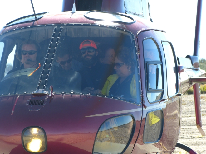
I was lucky enough to get a front seat.
Prior to this trip, we had toyed with the idea of rafting and camping through the canyon. Our ride on the snout rig absolutely settled that issue!
I’ll let you in on a little secret. Those rigs are not the most comfortable way to travel. And if you are seated in the front, you are guaranteed to get wet, even when there are no rapids. Guess what–the water is COLD.
Our land transportation, on the other hand, was luxurious. Good thing, because we traveled from one end of the canyon to the other: from Lake Mead to Lake Powell, logging many hours on that bus.
Our next stop was the one most visited by tourists–the south rim. The advantage to going a little later in the season was that the park was not crowded. Fortunately, we didn’t go TOO late. Had we waited another week, we would have found the park closed, thanks to our fine congressmen. But that’s another story.
There are so many possible captions for this next photo. “Death Wish”, “Just one more step back, honey”, “Did you send the check to the insurance company?”…
No, they were not with OUR group!
For the more adventurous, the South Rim offers the opportunity to hike (or ride) along Bright Angel Trail. Dinner at El Tovar was not part of our tour package, but we decided to forgo the Maswick Cafeteria and enjoy that beautiful setting.
Mike and Augusta on the porch at El Tovar
The next morning, while my two favorite traveling companions caught up on their beauty sleep, I returned to the edge of the rim to catch the sunrise.
I had the view pretty much to myself.
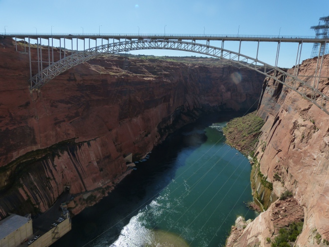
Our last leg of the journey was to Glen Canyon where we enjoyed another raft trip and a tour of the dam.
View of the dam from the river
If you look closely at the next photo, you will see our rafts on the left hand side of the river. We get there via a two mile tunnel carved through the rock.
View of river from the dam
Drew, our fantastic river guide, kept us informed and entertained, as he guided us down the river. A former Marine and lawyer, he chooses to spend his days piloting rafts on the river, and we all benefited greatly from that decision.
Drew explained the significance of the petroglyphs, including the “modern” one. Can you make out the word “Trent” carved into the rock? it seems Trent just had to leave his mark, and in doing so, he also contributed many dollars and hours of community service for defacing a historical site. Yep, he got caught.
Petroglyphs
Some people never learn. Once again, I sat in the front. Once again, I got SOAKED from head to toe.
We spent our final night in Marble Canyon.
Here it is–the town of Marble Canyon
The best part about being in such a remote area is the skies are magnificently dark. We were lucky enough to have a professional astronomer with us–Mike gave us a wonderful impromptu lecture on the heavens. It was a great finale to a fantastic trip!